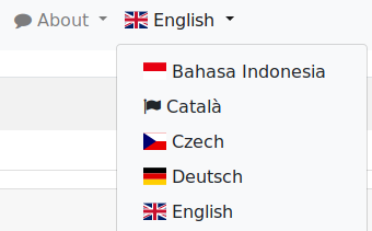
In recent weeks I have exeprimented with some user interface improvements again. None of these really changed the workflow, so they should be rather intuitive. But I still think that they improve the user experience a little bit.
Category: maposmatic
40,000 maps rendered
Last week this MapOSMatic instance processed its 40,000s map request, for a map of Sindelfingen, Germany.
While request numbers per day are fluctuating quite a bit there’s an obvious, but slow upwards trend, with typically over a hundred requests processed per day.
Fun fact: over the last year activity slowly shifted from peaks on weekends to higher activity on regular weekdays.
If you want to have a look for yourself: here are the Munin monitorign graphs
Upcoming Downtime, New Server
I’m preparing to move to new (faster and more affordable) server.
If all goes well I’ll move services over to the new machine on Sunday evening (September 30th, 18:00UTC).
During the switchover the service will be offline for an hour or two, for moving over existing rendering results to the new machine and doing some testing.
After that rendering should be a little bit faster as all databases will fit on the machines SSDs then, and there will be enough “rotating rust” HDD space for keeping rendered results around for a few months instead of just a some two weeks again.
Style updates
The OSM Carto standard style, and its German countarpart, have been upgraded to v4.15.0.
HTTP api now live, and new, shorter host names
The first public version of the HTTP API is now live, allowing you to submit render request from within your own applications.
Also new, shorter, host names now exist to access the service, instead of https://maposmatic.osm-baustelle.de/ you can now also use https://print.get-map.org/ and https://api.get-map.org/ , all of these being aliases for the same MapOSMatic instance.
There’s also API documentation, including a few simple PHP example programs, available as HTML and PDF
Site updates
I pushed some changes live today, there were a few gliches during the transition, but all things should be back to working state now.
Raw titleless maps
Style updates and additions
OpenStreetMap Carto, Waymarked, and OpenTopoMap styles have been updated. Belgian and Swiss styles have been added.
Frontend updates
I have updated the frontend code a bit, by finally upgrading to Bootstrap v3.x and by improving navigation between form parts of the “Create Map” form.
WayMarkedTrails routes DB reimport
Something has gone wrong with the regular updates of the routes database somehow, so I have to do a re-import of that data from scratch.
While this re-import is onging the WayMarkedTrails overlays will be disabled.
None of the other map styles and overlays will be affected though, so most of the service will continue to be available.