Hillshading – finally!

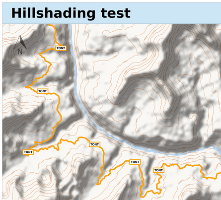
I was able to add the contour line overlay quite a while ago, with the actual contour line data generously provided by OpenSnowMap.

Unfortunately I couldn’t also provide hillshading data offered by OpenSnowMap, too, back then, as storage space on my previous server had already almost completey been used up.

I moved to a server with more storage space a little while ago already, and I now finally got to making hill shading work.

While I was on it I also added a variant of the contour line overlay that only renders contour lines for each 100m increment of height, instead of each 10m, so that maps don’t get overloaded by contour lines in mountaneous areas.

align=right

Small changes

Some small changes from last weekend:

  • The “Recreate” button was not really visible as a button, after changing the bootstrap button class it now is
  • The map list and detail pages now show the duration a request had to wait in the queue, and the actual time it took to render, in addition to the absolute submission, render astart, and end times
  • Most map styles use sans-serif fonts only, and so does the renderer for most map decorations, too. The only exception were index section headers, which was slightly visually disturbing. These have now been changed to use a sans-serif font, too.

Stylesheet statistics

As part of the preparation for my FOSSGIS talks on how to set up multiple Mapnik styles on the same server (more on this later) I did some statistics on which of the styles I offer on my MapOSMatic instance are the most favorite.

Below you will find the raw results. The OpenStreetMap Carto style is the leader by far, but that’s not much of a surprise as it is the default selection. The numbers for the runner ups are more more interesting, showing the HikeBikeMap as the most popular choice.

Continue reading “Stylesheet statistics”